We’ve reviewed three popular navigation apps to help you pick the best app for your needs. We’d love to hear your experiences with map apps, share them in the comments below.
4 Likes
I like the Google Map app but prefer to download the offline maps and use those for my travel. It helps avoid data usage while out and about, it is fairly well protected from loss of connection so even if out of mobile coverage my GPS data keeps me on track. With offline maps there can be the drawback of no traffic updates but it is a minor/non issue for us and our needs. I also regularly remove my usage/location data from the Google Databases (probably useless in terms of how they keep data but it makes me feel less observed).
3 Likes
My comments in the previous post about Car GPS apply also to this one as well.
2 Likes
ditto - my comments in other thread
Looks like I need revisit Waze. Tried it a couple of years back & gave it the flick after not adding any value over the other apps routes.
2 Likes
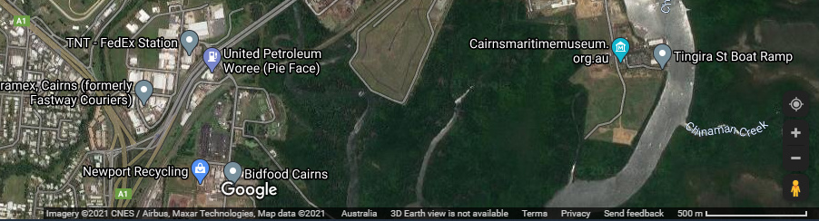
An article regarding complaints about Google Maps being out of date, especially with Street View.
The satellite imagery dated 2021 for our current home still shows vacant blocks nearby which have had residences built on them long ago, and the Street View image is dated 2007 when the subdivision had not been completed.
The Street View image for our previous home is dated 2015.
If Google Maps are this far behind in a major coastal city, what hope does the outback have?
1 Like
Google Maps doesn’t display the imagery date but the copyright date which is 2021. The copyright date shouldn’t be confused with the date the aerial photography image was taken. This the copyright date for the imagery shown for the Cairns area.
If one looks at Google Earth which uses the same imagery layers, it displays the image date. This is Google Earth extract showing the copyright date (down arrow) and the image capture date (up arrow)…showing that the dates are different.
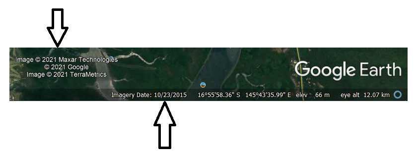
Google Earth has to purchase a licence to present the imagery. It is possible to get more recent imagery, but this may come at a cost depending on the source.
In Queensland one is lucky also have the State Government’s Queensland Globe.
The imagery presented on QGlobe is more current and usually only months to a year old in urban areas. The most recent imagery (in April 2021) for Cairns on QGlobe is dated 2020.
2 Likes
I was not aware of it, and it has much better resolution but does not seem to have a Street View.
Google Street View is/was created by their vehicles with the cameras on the roofs.
Pro version code is GEPFREE for personal use as far as I know as a free licence key. It still requires your email address as the user name.
Spot on. I use it often, mostly for land related mapping details which Google Earth does not provide.
In respect of roads the details of which roads are open or closed and the ‘correct’ names tends to be more reliable on the Queensland Globe.