Our experience of building in North QLD.
Flat land = lower costs to build.
We also found most builders avoided building anything other than a single story house on slab on a near perfect level block. Any imperfections were a cause for extras to build up or cut out and enable the possible.
We built on the fall of a significant hill. Bespoke construction apparently. Well above any flood level, but at the cost of a higher cyclone wind rating. Apparently little boxes in the flat with the eaves nearly touching can reduce the wind rating one or two categories. Savings on the cost to build, added profits? This rule applies to Melbourne and Sydney outer urban estates as much as it does to the tropical north.
P.S.
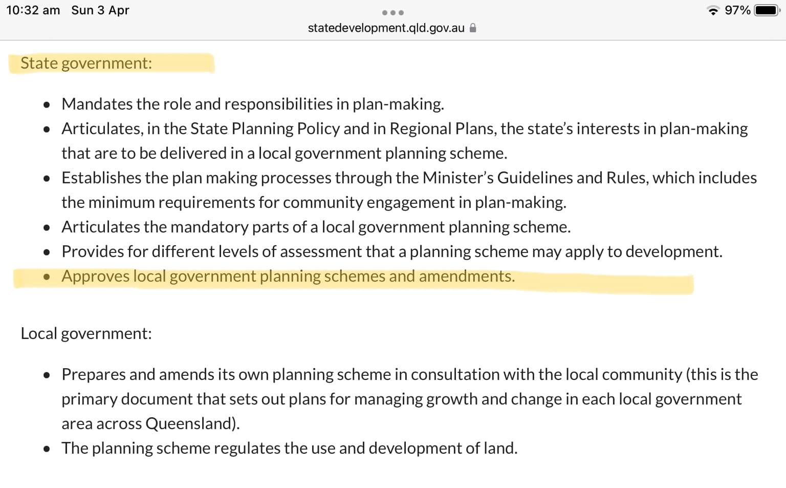
I’ve edited the topic to refer to Government in broad terms and just not councils. Councils are not the sole arbiters of building approvals. State and Territory Governments have also taken control of planing and development.
I find it strange that two naturally occurring risks to structures, wind and flood, are treated in such different ways.
With wind there is no attempt to tell you where to build but a formula that determines how strong the structure ought to be that depends on location. This is an Oz/Enzed standard that (in theory) applies Australia wide. How local building inspectors interpret it is another matter.
With flood it is nearly all based on location (in some cases the location can be modified by building on a platform) but AFAIK the nature of the structure doesn’t come into it. More important however is that decision making is all local and depends on whether the council has done a flood study, wants to grow their population by any means and if they feel obliged to save optimists from themselves or not.
It’s a point well made.
Anyone building in a high wind zone, bush fire zone or area subject to cyclones should be aware through the mandatory building requirements they are impacted. There are added building costs duly noted and compliance requirements listed in the quotes.
It’s a shared failure, at least in QLD. A rubber stamp perhaps, but not without a golden seal of approval from above.
In this example both LGA and State sign off multiple times to permit a residential or other zoning and subdivision leading to the sale of the land. Is there any wisdom subsequently refusing or restricting permission to build?
None, the question needs to be addressed before then. River flats are great for herds but ought not be zoned for houses. Not all housing developments follow that pattern of zone changing though.
It is possible that general approval for a house has been available on a title for decades and then the owner decides to apply for a DA. Consistency would be better and expectations would not be confused if the general right to build residences was re-assessed in the light of current flood assessments - ie the whole catchment map rather than each title. But local government does unfathomable things and (I suspect) they find it easier to argue single cases than many together.
All of the previous is about green field developments. The much harder situation is where historical approvals do not align with sensible current practice or when practice is not reviewed 'cause we are afraid of what it might reveal.
Just adding re cyclones & building requirements: my Mum & I live in Cairns. When she built her home 15-odd years ago, she found out from the builders(well known house & land package sellers) that her house would be built to only withstand Cat 1 cyclone. That was the standard, and that’s all they would do. So she had to pay extra to have the plans re-engineered or whatever, to increase it to Cat 2, which was all she could afford. This is in the bullseye zone for cyclones, yet all that was standard was Cat 1??? Cat 3 should be the standard up here.
There is a lot of relevant commentary from experiences around Houston TX USA, a place so freedom loving there is no zoning yet there are mandates for construction in flood plains. It is not a one sided view because weather is unpredictable and climate is changing, and so are flood plains for multiple reasons.
That information is inconsistent with my understanding. We have built in NQ and also purchased new. In the 1990’s and 2000’s. To be more correct houses are not rated by a wind code C1 lowest to C4 highest. It is a site assessment code. This is not the same ‘C’ as in the cyclone severity ‘Cat’ short for category used in warnings. A cyclone rated building on a site assessed as C1 is definitely designed for that site to withstand a Cat3 or more severe cyclone.
The basic design wind speed for any coastal wind zone in NQ is 250kph. This is greater than the peak sustained wind gust for a Cat3 cyclone of 165-224kph, and mid range for the peak wind gust due to a Cat4.
The attached provides an explanation on the design requirements for new houses and for rebuilding in North QLD. It’s a simplified version. The designers and certification requirements need to follow an Australian Standard. This considers the site and topographic impact on wind speeds, as well as distance from the coast.
Perhaps there has been a misunderstanding here? Paying extra for a stronger build designed for a more exposed C2 assessed site is not uncommon. It further reduces the risk of damage in the instance of the most severe Cat 4/5 cyclones.
Would the mass market developers offer that upgrade in their cookie cutter type offerings? How many who barely qualify as buyers willingly [can] pay extra?
No need for air, light, or access between them either.
Definitely no misunderstanding on her part, and house not at all in an exposed situation-old cane farm land, very inland, amongst other homes in new subdivision. I do have my doubts about the idiot liaison guy she had-WHOLE other thread there!! Many instances of mistrust, shall we say…
That is correct, and in the past developable areas have been based on the risk of inundation (called the Annual Exceedance Probability/AEP). For urban areas, this has been a probability of around 1%, with important infrastructure or assets being 0.5% or 0.2% or greater. These percentages have been seen as acceptable level of risk of inundation/flooding.
What many don’t realise is that unless development is confined to to tops of hills and mountains, any development in the lower areas of the landscape will be prone to flooding. It is a matter of time when flooding will occur. The probability of it occurring is the same from year to year, and because one has a flood one year, it doesn’t mean their won’t be a second flood in the same year or following years.
After the 1970 floods in Brisbane (from uni days and in our hydrology engineering lecture), there was a study done in relation to how members of the community retain knowledge of the risks of flooding. What was found is after a decade or slightly more, the community tended to dismiss the risk of flooding, even thought the probabilities remain the same. This is why house prices in flood affected areas decrease for a period after a flood and then bounce back many year later.
Are you sure? The usual definition of ‘flood’ is water on normally dry land that has backed up from an over full watercourse. Flooding is not the same as excessive groundwater flowing across the land that has not come from a water course.
There is plenty of Oz that is not on the top of a hill or mountain where the chance of flooding is minuscule or zero because water from the nearest watercourse will not reach it.
This is not just nitpicking because flood, groundwater and storm surge all cause water damage to structures but may be treated differently for insurance purposes.
Some development decisions are historical, and in hindsight, towns or cities wouldn’t be built in the same location if decisions were made today. A good mate recently read:
which opened his eyes to why Brisbane is located in the wrong location and how its catchment attributes to the flooding within the city (the catchment flood plain has a topographic constraint at the CBD - Kangaroo Point to the Valley for those who know the city which acts as a barrier/funnel when the river is in flood, increasing upstream flood levels). Flooding of urban areas been exacerbated by a number of other factors, including planning decisions. It makes an interesting read.
Maybe, maybe not. The oldest cities and towns grew like topsy when there were few, if any, zoning constraints. It was common for settlements to be established from the sea, including going up rivers by boat. Small settlements grew out from good landing spots.
Today we are looking at new suburbs and developments as offshoots of existing cities. But in the era of zoning restrictions developers still go looking for convenient flat or near flat land and that often means floodplains. Not only does this risk flooding but uses up arable land as is quite apparent in the Sydney basin.
Not all zoning restrictions have worked in practice and I have little confidence that they will in future. Just look at the newly recycled NSW Planning Minister Anthony Roberts who just conceded a bunch of building code and environmental rules in favour of the development industry. The pressure will not go away and all parties have weak politicians who decline to lead and are happy to be lead.
The oldest cities and towns were built adjacent to rivers for a number of reasons, access to shipping which was the main long distance form of transportation at the time, to provide reliable water for domestic, agricultural and industrial uses and in some cases to utilise the energy of flowing water. Their location has noting to do with zoning. Zoning became a planning tool in Australia in the 1960s/70s, well after establishment of towns and cities.
When Australia’s towns were first established, little was known about the hydrological landscape of the area, such as likelihood or severity of flooding. Decisions on location were made for other reason as outlined above. We are now living with the legacy of past decisions.
As the drivers for location have changed, and more is known about Australia’s hydrological landscapes, many cities and towns would possibly be located differently to where they are today.
Other than the knowledge of those who had been living in the same place for tens of thousands of years of course! We are slow learners some might suggest, although family history can be helpful.
Gundagai once stood on the flood plane of the Murrumbidgee River. All but three of the houses and one third (96 lives) of the population were lost in the 1852 flood. The town started to rebuild on the same spot and was hit with another flood in 1853. The townsite was subsequently rebuilt on two adjoining hills. Although as more recent floods reveal the development over time has continued in the wrong direction.
True. Even today when most of the original occupants have been displaced outside cities you can choose to ask people whose families have lived in the area for one or two hundred years. The present generation will tell you the stories of long ago and show you the marks where the water got to in the great flood years including those before their time. Plenty don’t bother to ask and so make their own life harder than need be.
Taking the beachfront properties of Sydney’s northern beaches as a somewhat similar example (they are affected by storms not floods) it has been known for well over 100 years that they are at risk in big seas with high tides etc. Still the (rather wealthy) owners complain and tell us somebody must do something, rather than take any responsibility for their decisions to buy there.